
Spanish Geography

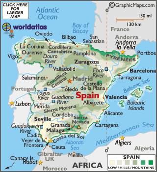

Occupying most of the Iberian Peninsula's land area (approximately 85%), Spain is the third largest country in Europe and 45% is covered by the Meseta Plateau.
That plateau is rarely flat, and is in reality a mostly hilly highland area divided by the Cordillera Central (mountains), and then ringed by additional mountain ranges, north, east and south. In the west the Meseta slopes gently down into neighboring Portugal.
Significant mountains in Spain include the limestone Cordillera Cantábrica and rugged Sistema Ibérico (north); massive Pyrenees (northeast) where many peaks exceed 3,000 meters and the lower Montes de Toledo.
In the far south the mountains of the Sistema Bético: Cordillera Subbética y Cordillera Penibética. Sierra Nevada dominates the landscape. Mainland Spain's highest point (Mulhacen at 3,481 meters) stands in the Sierra Nevada.
Significant lowlands include the fertile Andalusian Plain in the southwest, and the Ebro River Basin in the northeast. In addition, much of Spain is fronted by a low and narrow coastal plain, one that separates the mountains from the sea.
Those deeply indented coastal areas include countless bays and coves, and most have sandy beaches. In the far northwest, along the Bay of Biscay, rugged cliffs front the coastline.
In the far south, the Strait of Gibraltar separates Spain and Europe from Morocco (Africa), and here, the two continents are only 13 km (8 miles) apart.
The country is drained by an estimated 1,500 rivers (mostly small). The longest and most significant rivers include the Douro (Duero), Ebro, Jucar, Tagus (Tajo), Guadiana and Guadalquivir.
Out of the Península there are other Spanish territories: Canary Islands (In the Atlantic Ocean), Balearic Islands (in the Mediterranean Sea), Ceuta and Melilla in Northern Africa.